
"The old families of Virginia will form connections with low people, and sink into the mass of overseers' sons and daughters".
- John Randolph of Roanoke


History of the Park


The Historic Staunton River Foundation, a volunteer not-for-profit organization, was founded in 1994 to assist in the development, maintenance, and promotion of the Park.
This State Park has grown in recent years from a 6 1/2 acre undeveloped site to a 300 acre park with a full time park manager. It all started in 1910 when the widow of the owner of the land that included the earthworks decided to donate that site to four trustees; two Confederate Veterans from Charlotte County and two Sons of Confederate Veterans from Halifax County. They in turn were to see that it became a battle memorial site or park. For reasons not clear, nothing was done with the site until 1955 when the United Daughters of the Confederacy Chapter in Halifax County placed a monument at the site and requested the Commonwealth of Virginia to take ownership of the land. The General Assembly agreed and the department that is today known as the Department of Conservation and Recreation took ownership of the 6 1/2 acres with the earthworks. This site, which had become known as "Fort Hill" was assigned to the Staunton River State Park downstream near Scottburg but no funds were budgeted for its care, so it sat neglected for years. Some vandalism occurred as a result but the isolated location saved it from more extensive use and abuse. Nothing happened until the Old Dominion Electric Cooperative selected the property around the site for its new power station. The UDC and others appealed to ODEC to spare this historic battlefield area from development. What one sees today is the result.
In the early 1990's, as the power companies planned their power station, area citizens began to work on a plan to convert this old abandoned railroad bed into a rails-to-trails project from the "Fort" to Randolph and on to Keysville. They convinced the railroad to donate the railroad bridge and the 8/10 mile of railroad bed between the "Fort" and Randolph to the Virginia Department of Conservation and Recreation. DCR in turn made an application in 1993 for an ISTEA (Intermodial Surface Transportation Efficiency Act) grant. The grant application requested $780,560 for the project. The donated bridge and railroad property were listed as the required matching funds. The proposed project requested funds for restoration work on the earthworks, the decking of the steel railroad bridge over the River, the installation of two replacement bridges over the drainage ditches in the low grounds, and the surfacing of the railroad bed to transform it into an 8/10 mile trail to Randolph. The grant application was approved and the bridge was deeded to the state. The former Norfolk Southern property was officially opened as a trail from the Staunton River bridge to Randolph in a ribbon cutting ceremony on Nov 1, 1997.
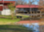
The Clover Center is the park's primary vistor's center and was built by the Clover Power Station, the power plant next door, which is owned jointly by the Old Dominion Electric Co-operative and Virginia Power. In June 1995 they donated the visitor's center and 85 acres of land to the Virginia Department of Conservation and Recreation. They retained the right to use half of the display area for exhibits on power generation and energy conservation. The other half is an exibit on the June 25, 1864, Battle of Staunton River Bridge.
In 1995, the Department of Conservation and Recreation applied for another ISTEA grant, this time for a "Staunton River Battlefield Enhancement" project. One million dollars were requested and the anticipated donation of the land and the visitor's center were used as the match. Included in the plans were the acquisition, relocation, and restroation of the 1910 Randolph depot, known as the Roanoke Station, cannons, interpretive exhibits and signs, additional earthwork improvements, and archaeological study, a picnic shelter, and a maintenance equipment shed were included. Approval was received for $500,000 and these projects were completed in 1999.
In 1996 the Historic Staunton River Foundation joined a consortium of organizations and localities in applying for an ISTEA grant to include additional sites, including the Staunton River Battlefield, in the Virginia Civil War Trails program. This program started in 1993 with the very popular "Lee's Retreat promotion. The 1996 grant was approved and Civil War Trails signs direct travelers to the park and advise them of this Civil War site. Also in 1996 the Civil War Trust included the park in its Civil War Discovery Trail program.
Old Dominion Electric Co-op, Virginia Power, the Virginia Department of Game and Inland Fisheries, and Ducks Unlimited combined their efforts in creating a waterfowl project in the wetlands along the Staunton River. Landmark Volunteer, with help from the Virginia National Guard, built in 1996 a nature trail and two observation towers over the wetlands. Both of these attractions and much of the impoundment for the waterfowl project are in the state park and easily accessible from the visitor's center.
During 1996 the state purchased the farm on the north side of the river and made it a part of the state park, increasing the total to about 300 acres. With that purchase came land on both sides of the railroad and from the river to Randolph. It insured the preservation of the battlefield over which the Union attacks were made and complements the bridge site and the earthworks the Confederates defended.
Randolph is the location of the depot, known as Roanoke Station, at the time of the battle. The station was burned by the Union as they left the scene. It was reported that some of their casualties burned inside. The depot that was built in 1910 still exists. Steamboats carried freight up the river and bateau came up the Roanoke Creek by Roanoke Station. A freight transfer station was located there to move freight from boat to train. The Randolph Post Office was once located in the depot.
The Mulberry Hill Plantation, where Mrs. McPhail told the Union officers of the trainloads of Confederate troops, is located up state road 641 from Randolph at the top of the hill. It was the headquarters of the Union force during their brief stay here. It has recently been donated to the State Park and is not yet open to the public although special events are held there. When opened to the public it will be an additional feature for visitors to enjoy.
Fort Hill is where the main effort was made to provide defenses for the bridge. A large depression in the ground there was a bomb proof powder magazine. The origin of the name "Fort Hill" is unknown, but it is the name by which the earthen fort has been known in later years. When the fort was abandoned as the Union forces approached the area, some of the cannons were thrown in a well inside the fort. Many years later, two war veterans fished one cannon out of the well. That barrel is now on display in front of the American Legion hall in South Boston, having been dedicated there as a memorial in 1940.
Captain Farinholt reported he had been here about 40 days before the battle preparing the defenses. That work had been assigned to a Captain E. N. Fitzhugh of the Confederate Engineers. Visitors can also see rifle pits outside the fort.
The Richmond and Danville Railroad was completed in 1865. In the 1890's it went bankrupt and emerged in 1894 as part of the Southern Railroad. Ninety years later, the Southern merged with the Norfolk to become the Norfolk Southern. By 1988 the section from Danville to Keysville had become abandoned, except for a short section from South Boston, which now serves the power station.
The bridge, here at the time of the battle, was a covered bridge and had a tin roof. During the last days of the war, after everything was safely evacuated from Richmond and passed through, the bridge was deliberately burned by Confederate troops. The entire inventory of rolling stock of the Richmond and Danville Railroad, in excess of 20 trains, was parked between the bridge and Danville. They could go no further as the Piedmont Railroad, connecting Danville with Greensboro, had a different gauge. Although it was discussed, there turned out not to be time to change the gauge to allow the trains to escape south before President Jefferson Davis left Danville and before the Union troops occupied the area. Immediately after the Union occupation, the bridge was rebuilt by Union forces and was a key transportation route for prisoners and Union soldiers returning home.
The present bridge was built in 1902. The piers are the original piers. The replacement bridge washed away in a flood in the fall of 1877 and again later that winter. As a result, the piers were raised 4 feet and looking closely today one can see the extensions that were added.
One of the first Confederate officers to report to Captain Farinholt, when the call went out for help, was Colonel Henry E. Coleman, of the 12th North Carolina Infantry. Colonel Coleman was from Halifax County and was in Halifax on wounded furlough. When he arrived he convinced Captain Farinholt that the bridge could best be defended on the north side. By 10:00 a.m., the day of the battle, a semi-circular work of slight profile was completed.
In response to the telegram sent to Danville, two companies totaling 150 men arrived in boxcars between 8 and 9 o'clock on the night before the battle. Captain James A. Hoyt, 1st Palmetto Sharpshooters (of South Carolina) was in charge of these two companies. They camped on the Halifax side that night but joined Colonel Coleman on this side shortly after daybreak the next day. Later that morning a company of ordnance personnel arrived from Clarksville. Captain Hurt and the home guard from Halifax arrived just as the battle started and some of these men crossed the bridge under fire. It was decided that Capt. Hoyt's two companies of regulars would take position at the right of the bridge, while Col. Coleman's "old Men and Young Boys" would occupy the left. The battle began about 4 o'clock in the afternoon. The heat was intense.
Additional Park Images
Return to History, Geneaology and Descendants


